See more reviews
()
+ 5
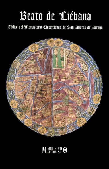
This double-page Mappa Mundi (±520 x 400 mm) lavish illumination is from the Girona Beatus manuscript. Made on a special paper that renders the feel and properties of parchment, this folio is a faithful reproduction to the one contained in the codex.
It is barely distinguishable from the original!
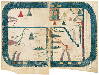
The mappa mundi in the Gerona Beatus stems from the one now missing from the Tábara codex. Its general characteristics are its rectangular shape, the representation of Adam and Eve instead of the four rivers of Paradise, and likewise the location of Paradise at the top of the maps, the appearance of the two possible courses of the Nile, a figuration of the Jordan, the representation of the Danube with many tributaries, the mention of the names of Cappadocia, Mesopotamia and the Arabia Gulf; a legend referring to the land of the Amazons and the new wording of legend about the fourth transequatorial continent.
The image covers two complete folios. The earth is depicted surrounded by a mass of wavy, blue water with drawings of triremes, fish, sea monsters, a large crab, a man inside a fish’s body – possibly alluding to Jonah – and square, ochre-coloured islands. The orb is rectangular in shape although its edges are rounded. The map is oriented with east at the top, like Christian temples. The earth is divided into three basic sections by means of water courses which correspond to those of the river Tanais (a group that comprised the Don, the Black Sea and the Aegean from the 7th century onwards and shown stretching from north to south), the Mediterranean (from east to west) and the Nile (from north to south and slanting from east to west), with the Red Sea being the boundary of the continents known at that time, as far as the fourth unknown continent. The coasts of the continent are wavy; the source of the blue river waters is a darker, round shape; the mountains are triangular or semi-triangular in shape with a scaly appearance; the islands, as already mentioned, are rectangular. Finally, the hot zone is depicted by means of a wavy, red band that represents fire and is separated from Asia and Africa by a strip of the ocean. This is a variety of the so-called Macrobianzone map whose horizontal divisions indicated the different climates of the world.
Read more
Read less
This double-page Mappa Mundi (±520 x 400 mm) lavish illumination is from the Girona Beatus manuscript. Made on a special paper that renders the feel and properties of parchment, this folio is a faithful reproduction to the one contained in the codex.
It is barely distinguishable from the original!
The mappa mundi in the Gerona Beatus stems from the one now missing from the Tábara codex. Its general characteristics are its rectangular shape, the representation of Adam and Eve instead of the four rivers of Paradise, and likewise the location of Paradise at the top of the maps, the appearance of the two possible courses of the Nile, a figuration of the Jordan, the representation of the Danube with many tributaries, the mention of the names of Cappadocia, Mesopotamia and the Arabia Gulf; a legend referring to the land of the Amazons and the new wording of legend about the fourth transequatorial continent.
The image covers two complete folios. The earth is depicted surrounded by a mass of wavy, blue water with drawings of triremes, fish, sea monsters, a large crab, a man inside a fish’s body – possibly alluding to Jonah – and square, ochre-coloured islands. The orb is rectangular in shape although its edges are rounded. The map is oriented with east at the top, like Christian temples. The earth is divided into three basic sections by means of water courses which correspond to those of the river Tanais (a group that comprised the Don, the Black Sea and the Aegean from the 7th century onwards and shown stretching from north to south), the Mediterranean (from east to west) and the Nile (from north to south and slanting from east to west), with the Red Sea being the boundary of the continents known at that time, as far as the fourth unknown continent. The coasts of the continent are wavy; the source of the blue river waters is a darker, round shape; the mountains are triangular or semi-triangular in shape with a scaly appearance; the islands, as already mentioned, are rectangular. Finally, the hot zone is depicted by means of a wavy, red band that represents fire and is separated from Asia and Africa by a strip of the ocean. This is a variety of the so-called Macrobianzone map whose horizontal divisions indicated the different climates of the world.