
THE ATLAS MILLER: A Trojan horse against Magellan’s project
Alfredo Pinheiro Marques
In 2003–2006, crown jewel of the Département des Cartes et Plans of the Bibliothéque nationale de France (BnF) – a celebrated nautical atlas of the world, familiarly known as the Atlas Miller of 1519–1522, – was published in Barcelona as a facsimile by the publishing house of Manuel Moleiro. For an accompanying volume, I wrote four essays: a summary of the origin and chronology of Portuguese geographic discoveries in the fifteenth and sixteenth centuries; an overview, with some radical new developments resulting from those discoveries of the origins and evolution of Portuguese cartography, including its first family ‘school’, i.e. the Reinel school; an in-depth study of the geographic and geopolitical content of the Atlas, revealing the nature and reasons why such an ostentatiously luxurious atlas was made; a study of its lavish decoration, and new information on the identity of the artist, the Luso-Flemish illuminator António de Holanda. Also Luís Filipe Reis Thomaz, leading specialist on the Portuguese presence in the Far East regions, contributed to the volume with a fifth essay. And a sixth essay, authored by both of us, covers the regional maps which are accompanied by an appendix containing transcriptions of the toponyms.
With global celebrations underway commemorating the quincentennial of the first circumnavigation by Ferdinand Magellan and Juan Sebastián Elcano, it is an opportune time to address the close and inextricable relationship between this voyage and the celebrated Atlas preserved in Paris. I will present a final summary of my findings regarding the Atlas’ curious and sensational geographical and geopolitical aspects and revisit the motivation, preparation and destination of this extremely lavish ‘map [intended] to deceive navigators’.
Ideas that were considered novel in the 2006 studies have, in the intervening years, become universally accepted. The decisive moment was when the BnF changed the identification, reference, file and the titles of the Atlas in its catalogues and exhibitions. It added the name of the illuminator António de Holanda to its list of the authors and identified them as ‘Atlas by Lopo Homem [with Pedro Reinel, Jorge Reinel, and António de Holanda]’.
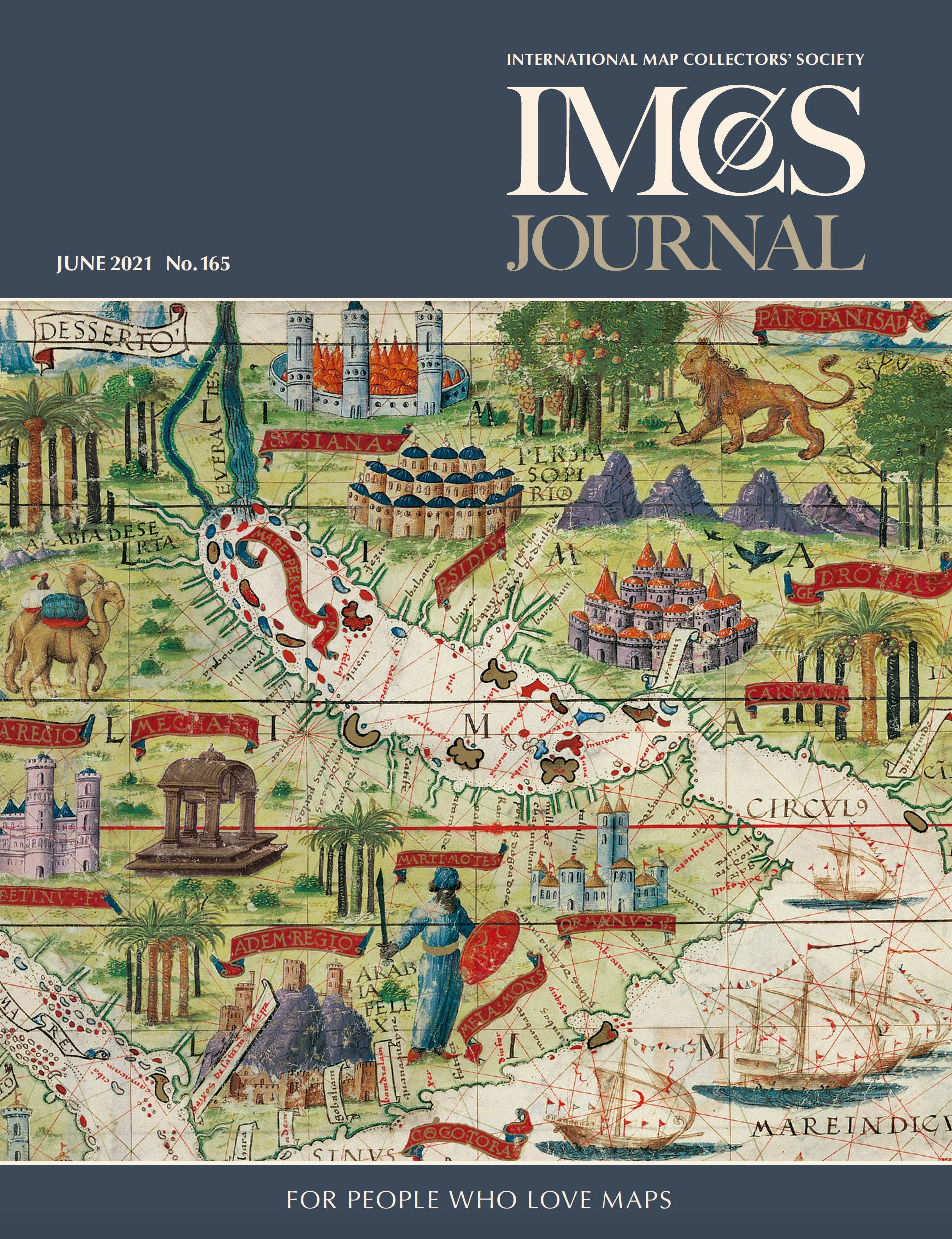
In its current state the Atlas Miller, so called after Clément Miller from whose estate it was acquired in 1897 (ref.: GE DD 683 [2-5 RES]), is a set of separate parchment folios. Five measure 42 × 59 cm. These include the world map which has the frontispiece on the reverse with mention of Lopo Homem and the date, and four folios which have charts on both sides depicting the geographical areas of the Indian Ocean north and south, the China Sea, the Moluccas, Brazil and the South Atlantic Ocean, North Atlantic and northern Europe.
They are complemented by a larger fifth ‘folio’ (about 61 × 118 cm) made up of two parchments stuck together back-to-back (ref.: GE AA 640 [RES]). The Atlantic Ocean is depicted on the recto and the Mediterranean on the reverse. Based on the crease folds it was concluded that all these folios had once been part of the same set (the world map and the four regional maps had been folded in half and the larger ‘folio’ had been folded in four with the upper and lower edges turned back). They were bound together to make a kind of ‘atlas’ that measured approximately 42 × 30 cm. At an unknown date it was disassembled, after which the folio depicting Africa disappeared. Moreover, and significantly, even though this ‘atlas’ or collection sought to represent the entire planet, the pages that should have depicted the other side of the world, between the Far East (‘Magnus Golfus Chinarum’) and the New World (Brazil), were left incomplete (one of them only has the wind rose lines and the other is entirely blank).
The Atlas is richly decorated, painted in the style of a Flemish book of hours by Flemish miniaturist António de Holanda, about whom little is known. We know he was entrusted as royal heraldic official and had married into the family of the cartographer Lopo Homem.
The Atlas as a whole – not just its ‘Neo-Ptolemaic’ world map, which is dated and signed – but the regional portolan charts also date from 1519 to c. 1522.
Why was the atlas made?
In 1519, on the orders of King Manuel I of Portugal (r. 1495–1521), the cartographers Lopo Homem, Pedro Reinel and Jorge Reinel, along with the illuminator António de Holanda who had recently come to Portugal, created this lavish atlas of nautical maps. Decorated as though it was a Flemish book of hours, it was intended for the young Flemish princess Leonor who became the Queen of Portugal on her marriage to Manuel I in the previous year. Leonor, the eldest child of Philip of Austria and Joanna of Castile and the sister of Charles V, was nineteen years old at the time. She was widowed three years later and left Portugal in 1523 and, in my opinion, took with her the unfinished Atlas.
The very fact that the Atlas was left unfinished with pages 20 and 21 yet to be completed is definitive proof that Manuel I never intended it to be sent as a state gift to some European dignitary such as the King of France or the Pope.
It has been my view since 2005–2006 that the Atlas is a deliberate geographical deception, designed as a lavish tool for diplomatic and geopolitical counterinformation. It was expressly commissioned to try and thwart the idea that the Earth could be circumnavigated and thus prevent the project that at precisely the same time, during 1519, was being prepared in Seville by Ferdinand Magellan. A voyage to reach the Far East by sailing via the western hemisphere (later assigned to Spain by the Treaty of Tordesillas) was the longstanding dream of Columbus and the Castilians. Portugal was determined to refute Columbus’s plan to reach India by sailing westward. The diplomatic and political aspects of its creation and the purpose for which Manuel I commissioned it were clear: to influence his young and highly-regarded brother-in-law, Charles V, who in 1519 was a new monarch recently arrived from Flanders, King of the Crowns of Castile and Aragon (and hence King of Spain), and shortly thereafter elected Emperor of the Holy Roman Empire. The Portuguese intended to:
use the Atlas Miller as a tool for geo-strategic, geopolitical and diplomatic misinformation, trying to make the Castilians – esteemed neighbours, rival siblings and cordial competitors – believe two things. First, they tried to make the Castilians believe that it was more than very difficult to reach the Orient (India, Malacca, China, Japan [which they called Cipango] and the Moluccas) via the western route. The Castilians had known this since Columbus’ time, but were still trying to get there, showing increasing insistence and stubbornness and using Portuguese navigators such as João Dias de Solis in the Gulf of Mexico (1508–1509) and the River Plate (1515–1516). The Portuguese worked hard to make the Castilians think this plan was simply impossible because the New World was a continent, because the land on the planet was too big and continuous, and the seas too small and closed. As the prophet Esdras and Bishop Jacob Pérez of Valencia said (and Pacheco repeated), there was seven times as much land as there was water, and there was consequently no way of sailing west to the Orient. Secondly, they tried to make the Castilians believe that the Cape route to India – the Portuguese southeast African route that was diplomatically safeguarded by the Luso-Castilian Treaty of Tordesillas and was therefore unchallengeable and unchallenged by Portugal’s neighbours – was a very easy one. It [the distance] was short – very short in fact, since Africa itself was also small – and India was just around the corner after rounding the Cape of Good Hope. Thus, the subject was closed and India was in safe hands. Consequently, it would be better if Charles V and the Castilians gave up and concentrated on marrying their princesses – one after another – to the old “King of Pepper” and Master of the Cape Route.
Manuel’s commission was made to counter Magellan’s voyage and Magellan’s voyage made to counter the Atlas. This is particularly noticeable in the ‘world map which was made deliberately “fake” by its authors’. The map shows a world in which all the seas have been joined together into a kind of great lake at the centre of the Earth. The land mass has been disproportionally enlarged. This is a concept influenced by Ptolemy, a strange Neo-Ptolemaic type which was, at the time of making the map, anachronistic and archaic. It is particularly surprising and strange that it appeared in Portuguese cartography which had never been especially influenced by Ptolemy. Much to the contrary, Portuguese mapmakers had been the most pioneering and geographically accurate with regard to portolan charts of the Atlantic and Indian Ocean regions and, for decades, had contributed more than any others towards overcoming Ptolemaic concepts.
This strange vision of the cosmos was defended by seasoned sea captain and navigator, Duarte Pacheco Pereira, who had been employed as official geographer to King João II and, in 1494, served him at the signing of the Treaty of Tordesillas. Pereira subsequently served his successor, King Manuel. In his work entitled De Situ Orbis he surprisingly supported precisely this concept – and for the same reasons.
Controversies over the paradoxical enigma of the ‘fake’ nature of the world map raged for decades amongst some of the most renowned historians of map history such as Giuseppe Caraci, Armando Cortesão, Marcel Destombes, Albert Kammerer, Edward Heawood, etc. Some found it difficult to understand and explain the extremely strange and very surprising way in which this geographical masterpiece managed to contain, side-by-side in happy coexistence, as though there was no contradiction at all, a curious world map and a series of regional maps which, in terms of their geographical aspects, were simply typical portolan charts in the manner of Pedro Reinel. However, historians – such as Marcel Destombes and Armando Cortesão – accepted that the world map was real and coeval, that it had once been included in the same codex with the regional maps and had been made by the same authors linked to the production and decoration of the regional portolan charts.
The debate was finally resolved in 2005–2006 in Coimbra and Barcelona with the publication of my research. It was agreed that the geographical content – relating to the (non-) circumnavigability of the Earth, the Terra Austral and the (fantastic and totally false) geography of the Far East – was deliberately erroneous and that the ‘Neo-Ptolemaic’ form was intended to disguise this deception.
The Portuguese had perpetuated this disinformation throughout the reign of the ‘Fortunate’ King Manuel. It was evident in the work of Pereira, c. 1505–1508, in his [Esmeraldo] De Situ Orbis and in Duarte Galvão’s beautifully illuminated Crónica de D. Afonso Henriques, a vernacular chronicle of Afonso Henriques, first king of Portugal, commissioned by Manuel I. On the frontispiece of a 1519 copy of the manuscript is a small terrestrial globe flanked by two angels; it shows Portugal’s hemisphere according to the Treaty of Tordesillas. The globe is edged with a continuous land mass depicting a Ptolemaic rendering of the world similar to the Atlas Miller world map. I identified the artwork in 1993–1994 and attributed it to António de Holanda at the same time as identifying him as the artist responsible for the Atlas Miller world map.
In 2005–2006 I published that this very same geographic and geopolitical counter-information disseminating from Portugal resulted in a surprising shift in the evolution (or perhaps it would be better to say ‘in the strange regression’) of the geography in Martin Waldseemu?ller’s celebrated maps: from the famous 1507 map and the extremely influential map dating from 1513 to the intriguing ‘Carta Marina Navigatoria Portugallen[sia] Navigationes…’ dating from 1516, in which the great cartographer who had always been heavily influenced by the Portuguese, surprisingly reversed course and did a volte-face with regard to his earlier pioneering work, from 1507, which depicted a separate New World. This was the same geopolitical deception that Pacheco Pereira and Portuguese cartographers were promoting immediately prior to the Magellan-Elcano voyage.
The Atlas represents the last Portuguese attempt to try and thwart the Castilian project to sail to Asia via the west. The project had been conceived by Paolo dal Pozzo Toscanelli and Fernão Teles de Meneses in 1474, and was subsequently appropriated and attempted by Christopher Columbus in 1492–1493 on behalf of Castile. He failed to reach the coveted Spice Islands, instead stumbling on the Americas. The final and definitive attempt was being prepared in 1519 in Seville for the Crown of Castile by a Portuguese team: Ferdinand Magellan, who had been spurned by Portugal and went to serve the neighbouring kingdom in 1517; Rui Faleiro principle scientific organiser, and the cartographers Jorge Reinel and Diego Ribeiro. The expedition was commanded by Magellan, a veteran of the Far East where he had been with the Portuguese captain Afonso de Albuquerque and others. He took with him dozens of Portuguese crew members (some of whom disguised their nationality) and, of the pilots who accompanied him, most were Portuguese: João Lopes de Carvalho, João Serrão, Estêvão Gomes, Álvaro de Mesquita, Duarte Barbosa, Vasco Galego. The fleet of five old and repaired ships set sail in 1519 and, after incredible effort and determination, discovered the Magellan Strait, traversed the Pacific Ocean and reached the Philippines, where the commander was killed in a chance encounter with local people. Of the five ships that set out only Victoria, now captained by Juan Sebastián Elcano, a Basque from Getaria, managed to complete the return journey, surreptitiously sailing the Portuguese route via the Cape of Good Hope. That ship was the only vessel to return to Castile in 1522. Trinidad, the one other ship to have survived the journey to the Moluccas was captured by the Portuguese.
The dispute between the Castilians and Portuguese following the Magellan-Elcano voyage, which proved that the globe could be circumnavigated (and which reality the Atlas did not reflect) created a complex diplomatic situation. It was related to the Moluccas which the Spanish, after their successful circumnavigation, claimed were in fact situated in their hemisphere. With the technological resources available at the time it was absolutely impossible for either party to scientifically ascertain the actual longitudinal location of the demarcation line of the Treaty of Tordesillas. In 1524, a meeting held in Badajoz (Spain) and Elvas (Portugal), aimed at resolving the disagreement between the crowns of Portugal and Castile failed to reach an acceptable consensus. Everything seems to indicate that the head negotiator for the Portuguese, nobleman Diogo Lopes de Sequeira, was secretly working for the opposition. A ruinous treaty for the Portuguese was finally signed in Zaragoza in 1529 and the King of Portugal – who, in the meantime, had married another of Charles V’s sisters in 1525 – accepted that the Spice Islands belonged to the Castilian hemisphere. He agreed to remunerate them 350,000 ducats, a vast sum of money, for the islands. He thus paid for possession of an overseas territory that in practice Portugal already controlled, and for which it had had a trading monopoly, for more than fifteen years. Castile’s access to the islands via their hemisphere was at the time economically unviable – the passage there was too difficult and the return journey across the Pacific impossible, as was evident from the failure of the only subsequent Castilian expedition, the 1525–1526 voyage commanded by García Jofre de Loaysa.
Without doubt Portuguese interests in the Moluccas and the Far East were badly defended by Diogo Lopes de Sequeira, who in the meanwhile had been elevated to the governor of the Portuguese Indies (1518–22). This was the same individual who, in 1509, commanding the first Portuguese fleet to Malacca, almost had his fleet captured there while preoccupied playing chess. On that occasion the disaster was averted by a young and vigilant officer – Ferdinand Magellan – who clearly displayed his potential as a future commander!
Pedro and Jorge Reinel
One of my essays accompanying the 2006 Moleiro facsimile shed new light on the origins of the cartography of the Portuguese discoveries of the fifteenth to sixteenth centuries, in particular the first known family ‘school’ of cartography. Pedro Reinel, an official cartographer in Lisbon who had served during the reigns of Kings João II, Manuel I and João III, and his son Jorge were the earliest known cartographers whose works effectively contributed to Portuguese and European colonial expansion and geographical discoveries.
During various months of 1519 the two men worked on two projects: creating the Atlas in Lisbon as well as helping on preparations for Magellan’s voyage in Seville. Jorge, a young lad, had allowed himself to be enticed, just like Diego Ribeiro and others, to cross the border to Seville. However, when his father went there to bring him back to Portugal in June or July 1519 (probably having been told to do so by the Portuguese authorities), he himself, before returning with Jorge, also drew or completed some nautical chart for the Castilian expedition. According to the Portuguese consul and commercial factor (and spy) in Seville, in one of his messages sent to Lisbon, dated 18 July 1519, he wrote that the Portuguese cartographer Diego Ribeiro had made the charts that were to be used for the Magellan expedition, and had made them by copying a master map drawn by the ‘Reinel son’, which the father himself completed when he went to fetch his son. The Reinels returned to Portugal but Ribeiro stayed on in Castile in perpetuity to serve the Crown, working at the Casa de la Contratación in Seville and at the Casa de la Contratación in La Coruña, etc.
There is no doubt that cartography – then (as always) – was especially appreciated, useful and necessary for politics, diplomacy, information and intelligence. Skilled and knowledgeable mapmakers were highly sought after, everywhere; they were extremely valuable agents and were treated as such. Documented proof, which has long been known, reveals that a second attempt at recruiting Pedro and Jorge took place five years later in 1524 after the surviving members of the Magellan-Elcano expedition had returned and during the international diplomatic negotiations in Badajoz and Elvas. This attempt to entice them to serve the crown of Castile failed. Pedro reported the incidence to the Portuguese authorities and, along with his son, continued to serve Portugal.
My research also concluded that, surprisingly, the two men were referred to by their compatriots as ‘Negros’ [sic!], indicating that they were of mixed origin. This discovery, I made in 2005-2005, can be explained by the cosmopolitan nature of the city where the Atlas was drawn and decorated. Lisbon was a hub for transoceanic trade at the time. Just as in other centres from where voyages of ‘Portuguese discoveries’ set sail such as Montemor-o-Velho and the Beira Litoral (where the European branch of the Reinel family, squires to the Duchy of Coimbra, originated), there was a significant presence of foreigners. It was no coincidence that António de Holanda, in the 1519 world map, instead of drawing the faces of the winds blowing in the four directions in the form of traditional putti (as was habitual in Ptolemaic cartography and Italian art), pictured them in an exotic manner as four young Africans. Similarly, it was no coincidence that, during that same period, in Montemor-o-Velho c. 1515, the tomb of the veteran navigator Diogo de Azambuja – who built the famous castle at Mina (Elmina, in modern-day Ghana) for King João II, the source of Portugal’s wealth due to the bounteous gold procured from Guinea – was adorned with a sculpture depicting an impressive image of a young squire with African features, serving as an equerry, witnessing the death of his lord (or perhaps father?).
Pedro and Jorge Reinel were two of the best cartographers of their time and the first circumnavigation of the planet Earth was prepared in Seville based on their knowledge. At more or less the same time, in that extraordinary year of 1519, the Atlas was created in Lisbon, similarly based on their geographical knowledge, this time for the Crown of Portugal. It was paradoxically commissioned precisely to try and thwart that very same circumnavigation and might be considered as the greatest (attempted) geopolitical falsification in history – or, at least, the greatest in geographical terms – as it was the first deception that had, or sought to have, a planetary dimension. It proved to be in vain as Magellan’s ships nonetheless set sail, carried out their voyage and realised the long-held Castilian ambition.
Such a work, which reflected the best science and the best art available at the time, could only have been produced at that time in a country such as Portugal. A country in which Luso-Flemish Portuguese rubbed shoulders with Luso-African Portuguese. A country in which, at that time, three men, a ‘Negro ’ cartographer, an Iberian aristocrat and a Flemish painter – Pedro Reinel, Lopo Homem and António de Holanda – could meet and form an unlikely partnership, joining forces to create such a fascinating masterpiece.
Since 1982 Alfredo Pinheiro Marques has lectured at Portuguese and foreign universities, and in 1988 was the scientific coordinator of the Portuguese commission for the Universal Exhibition of Seville/Columbus Celebration (EXPO 92). He authored the ‘Addenda’ for the new edition of Portugaliae Monumenta Cartographica in 1987 and in 1992 he created his International Bibliography of the Discoveries and Overseas Encounters. Among his books are the Guia de História dos Descobrimentos e Expansão Portuguesa [Guide for the History of Portuguese Discoveries and Expansion] (1988), and A Maldição da Memória do Infante Dom Pedro e as Origens dos Descobrimentos Portugueses [The Accursed Heritage of Prince Peter and the Origins of the Portuguese Discoveries] (1995).