Atlas Miller

The Azores


Back

 The surviving chart that illustrates the Azores is the left half of what was once an entire chart. Besides the Insule Ancipitrum (Azores) and another large rectangular and invented island called Insula Viridis, it only has some illuminations of ships and some wind-roses. When still complete, this chart would have shown the waters of the Atlantic off the Iberian Peninsula and a part of the peninsula, stretching only slightly further east than Portugal. It was essentially a portolan chart that, despite being decorated, could clearly be used for navigational purposes. The directions were established by the usual sixteen rhumb lines whose centre was located somewhere in the Atlantic between the Azores and Portugal. Since only the left half of the chart has survived, just nine intersections of these rhumb lines can now be seen. Two complete and two half wind-roses are visible in this section. As is also true of the remaining charts in the Atlas Miller, none of these wind-roses has the later fleur-de-lis shaped indicator pointing north, instead showing pawn-shaped indicators. The scale appears in the middle of the ocean, but the meridian with latitude graduations that the chart would probably have (like the others in this atlas) is not now visible, and most probably appeared on the eastern edge of the missing right half. The chart also includes four parallels or climate circles, corresponding to Ptolemy’s fourth, fifth, sixth and seventh climates, while the only place-names are those of the islands, which are already both accurate and definitive. Moreover, there is no main caption with a text in Latin, which must either have been in the lost other half, or more probably never even existed. The chart also shows three large Portuguese vessels that every year sailed off the Azores to use the favourable winds on their return from the India Route. There is no heraldic iconography involving flags or shields (not even on the islands), nor yet any other type of imagery (human, fauna or flora).
 
Alfredo Pinheiro Marques
Centro do Estudos do Mar Luís de Albuquerque
(Fragment of the Atlas MIller commentary volume)
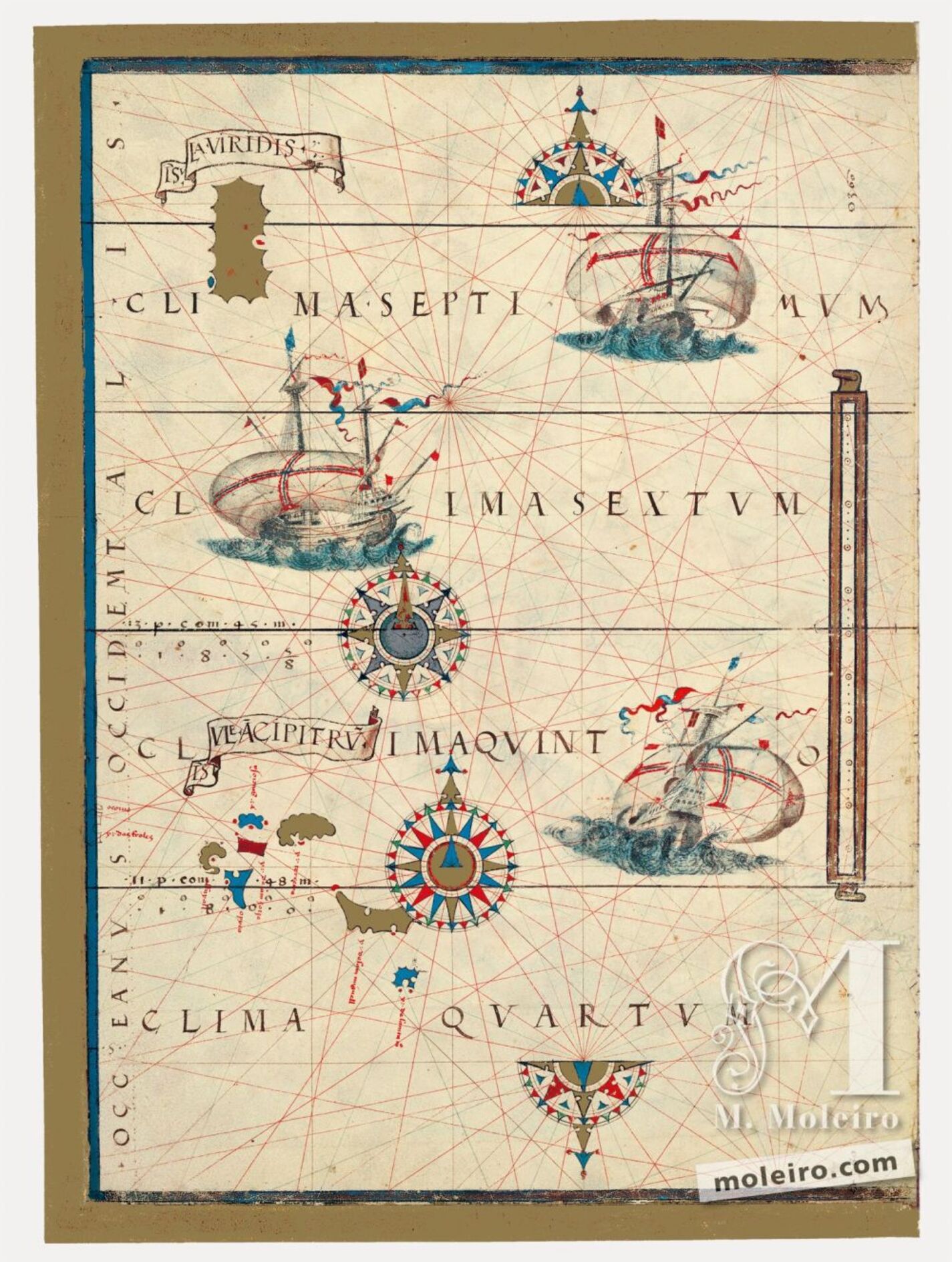


Islas Azores

Back

The Azores

 The surviving chart that illustrates the Azores is the left half of what was once an entire chart. Besides the Insule Ancipitrum (Azores) and another large rectangular and invented island called Insula Viridis, it only has some illuminations of ships and some wind-roses. When still complete, this chart would have shown the waters of the Atlantic off the Iberian Peninsula and a part of the peninsula, stretching only slightly further east than Portugal. It was essentially a portolan chart that, despite being decorated, could clearly be used for navigational purposes. The directions were established by the usual sixteen rhumb lines whose centre was located somewhere in the Atlantic between the Azores and Portugal. Since only the left half of the chart has survived, just nine intersections of these rhumb lines can now be seen. Two complete and two half wind-roses are visible in this section. As is also true of the remaining charts in the Atlas Miller, none of these wind-roses has the later fleur-de-lis shaped indicator pointing north, instead showing pawn-shaped indicators. The scale appears in the middle of the ocean, but the meridian with latitude graduations that the chart would probably have (like the others in this atlas) is not now visible, and most probably appeared on the eastern edge of the missing right half. The chart also includes four parallels or climate circles, corresponding to Ptolemy’s fourth, fifth, sixth and seventh climates, while the only place-names are those of the islands, which are already both accurate and definitive. Moreover, there is no main caption with a text in Latin, which must either have been in the lost other half, or more probably never even existed. The chart also shows three large Portuguese vessels that every year sailed off the Azores to use the favourable winds on their return from the India Route. There is no heraldic iconography involving flags or shields (not even on the islands), nor yet any other type of imagery (human, fauna or flora).
 
Alfredo Pinheiro Marques
Centro do Estudos do Mar Luís de Albuquerque
(Fragment of the Atlas MIller commentary volume)


Cookie preferences

We use cookies and third-party cookies to improve our services by analyzing your browsing habits. For more information you can read our cookie policy. You can accept all cookies by clicking the Accept button or configure or reject their use by clicking HERE.