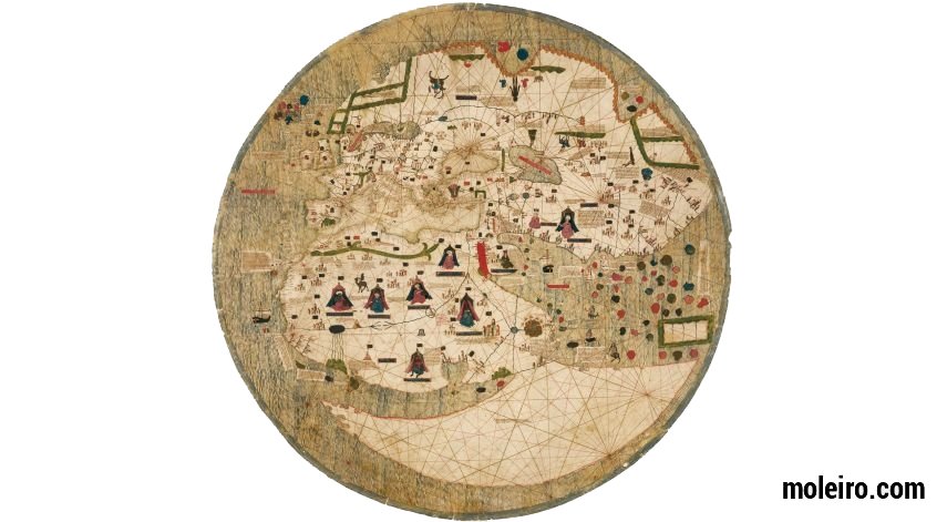
In the 14th century the Catalonia-Valencia-Majorca region was a flourishing centre of trade and culture where Arab and Jewish elements blended with Christian culture. Countless maps by this cartographic school have survived including the Estense World Map featuring characteristics typical of portulans – rhumb lines, and flags and coats of arms to identify kingdoms and cities – but this map was obviously not made as a navigation aid. It can be considered to be a paradigm of the artist’s technique, logical extensions of his vision extending beyond the Mediterranean to the frontiers of the known world. The anonymous artist of the Estense World Map combined details from literature of certain regions of the world with empirical facts about the Mediterranean area, the zone he knew best. As a result, details from the tales of Marco Polo, known centuries before, can be seen in the descriptive outline of China, with details about the recent Portuguese explorations of Cape Verde, circumnavigated for the first time in 1444 by Dias too. Religion is also present in this map, not only due to the circular shape but also because of the drawing of Paradise, depicted in eastern Africa and not in Asia as was usual.
The most curious geographic characteristic is the shape of Africa. On the edge of the Gulf of Guinea, a river or strait connects the Atlantic and the Indian Oceans and an enormous land mass emerges to complete the base of the map. No place name is given and it is not clear whether it is considered to be part of Africa or another continent. Stylistically speaking, the most noteworthy characteristic of the Catalan school is the series of portraits of the lords of the desert in their tents, some of whom are actual sultans and others legendary figures. These are the earliest European maps to acknowledge and record the presence of Islamic power in the Mediterranean.
This map is of interest because of its uncertain and eclectic identity. Circular in shape, with different religious and legendary motifs along with certain Arab influences, it retains the rigor of portulans. It has no titles, dedications or notes offering any clue to its intended use. Such a highly complex map implies several unknown factors as regards the level of realism aimed at by the artist. But to what extent did his contemporaries really believe what they saw in his drawings? It is, for example, inconceivable that professional seafarers believed the large, even expanse of land to actually exist in the south of Africa. Or that the scientists of New Humanism believed that kings with dogs’ faces did exist. Or that theologians could accept that Paradise, which ceased to appear in Asia following Marco Polo’s travels, could be relocated to Ethiopia. It is difficult to imagine that they believed that the laws of God and nature ceased to apply beyond the frontiers of Europe and that anything was possible there. It is more logical to think that this map depicts different levels of representation.