Map of Canada and North America from the Vallard Atlas (1547)
1 IDENTICAL ILLUMINATION
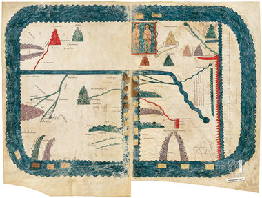
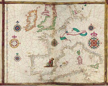
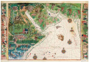
This chart is an exact replica of the map nº 9 (Canada and North America) from the Vallard Atlas (1547), made on a special paper that renders the feel and properties of parchment.
The Vallard Atlas, ascribed to the Dieppe cartography school, has a clearly Portuguese flavour. This map is one of the most significant of the Vallard Atlas. Like all the others it is oriented to the South and has the latitude markers and distance scales in the left and right margins. In the Atlantic, almost in the center of the map is one beautiful ship, partially surrounded by compass roses, exuding rhumb lines. What makes this map particularly important is its display of the geographical information brought back from the New World by the expeditions of Jacques Cartier in 1534, 1535-1536, and 1541-1542. Detailed are the Gulf of St Lawrence and the St Lawrence River and some of the wilderness beyond them, discovered and explored by Cartier in search of the elusive Northwest Passage to the Orient and who gave Canada its name.
We use our own and third-party cookies to improve our services by analyzing your browsing habits. For more information, you can read our cookie policy. You can accept all cookies, configure them, or reject their use by clicking one of the buttons below.
 1 IDENTICAL ILLUMINATION")
 1 IDENTICAL ILLUMINATION")
 1 IDENTICAL ILLUMINATION")
 1 IDENTICAL ILLUMINATION")