")
")
")
")
")
See more reviews
()
+ 2
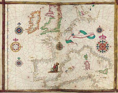
Facsimile Map from the Vallard Atlas (1547)
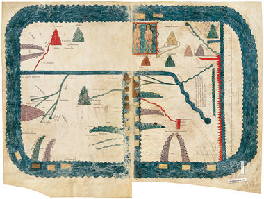
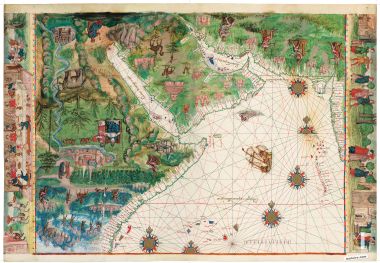
This map of the Persian Gulf and the Red Sea belongs to the famous Vallard Atlas (1547), one of the most beautiful works produced by the Dieppe cartographic school. The original manuscript is preserved today at The Huntington Library (San Marino, California). This richly illuminated nautical chart reflects the geographical knowledge of the 16th century and the Portuguese influence in the exploration of the Indian Ocean.
Oriented with the south at the top, it represents the coasts of Arabia, Persia, western India and the Horn of Africa. It also includes the strategic Strait of Hormuz, a key passage between the Persian Gulf and the Indian Ocean. These regions correspond today to territories of Iran, Saudi Arabia, Yemen, Oman, India, Somalia, Eritrea and Sudan.
As in most 16th century portolan charts, the chart mainly shows ports and coastal place names used by navigators. The interior regions are decorated with miniatures representing fortified cities, rulers and symbolic scenes typical of Renaissance cartography.
Among the most interesting details are the representations of Mecca and Medina on the Arabian Peninsula, the legendary Prester John in Ethiopia, and several ports of the East African coast known to Portuguese navigators.
This sheet is printed on vegetable parchment using three different printing techniques: screen printing base layer, offset printing and metallic stamping for the gold areas, faithfully reproducing the original map of the Vallard Atlas. Valued by collectors of antique maps, it also works beautifully as antique map wall art or elegant wall decoration. Size: 28 x 39 cm (11.02 x 15.35 in).
Read more
Read less
This map of the Persian Gulf and the Red Sea belongs to the famous Vallard Atlas (1547), one of the most beautiful works produced by the Dieppe cartographic school. The original manuscript is preserved today at The Huntington Library (San Marino, California). This richly illuminated nautical chart reflects the geographical knowledge of the 16th century and the Portuguese influence in the exploration of the Indian Ocean.
Oriented with the south at the top, it represents the coasts of Arabia, Persia, western India and the Horn of Africa. It also includes the strategic Strait of Hormuz, a key passage between the Persian Gulf and the Indian Ocean. These regions correspond today to territories of Iran, Saudi Arabia, Yemen, Oman, India, Somalia, Eritrea and Sudan.
As in most 16th century portolan charts, the chart mainly shows ports and coastal place names used by navigators. The interior regions are decorated with miniatures representing fortified cities, rulers and symbolic scenes typical of Renaissance cartography.
Among the most interesting details are the representations of Mecca and Medina on the Arabian Peninsula, the legendary Prester John in Ethiopia, and several ports of the East African coast known to Portuguese navigators.
This sheet is printed on vegetable parchment using three different printing techniques: screen printing base layer, offset printing and metallic stamping for the gold areas, faithfully reproducing the original map of the Vallard Atlas. Valued by collectors of antique maps, it also works beautifully as antique map wall art or elegant wall decoration. Size: 28 x 39 cm (11.02 x 15.35 in).