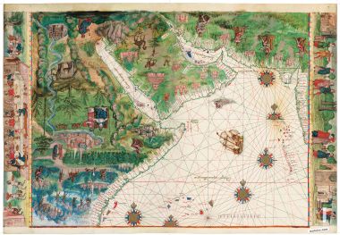
Map of Central America and the Antilles from the Vallard Atlas
1 IDENTICAL ILLUMINATION
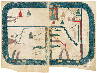
This chart is an exact replica of map nº 10 (Central America and the Antilles) from the Vallard Atlas (1547), made on a special paper that renders the feel and properties of parchment.
The Vallard Atlas, ascribed to the Dieppe cartography school, has a clearly Portuguese flavour due to either its anonymous creator or the model that inspired it. The map of the Caribbean Sea and Gulf of Mexico regions is exceptional for its accuracy at this time. It is reflective of its Iberian cartographic sources, as exemplified by the northern coast of the Gulf of Mexico and by the Yucatan Peninsula. With its high degree of exactness, as a French map it also proclaims a northern European challenge to the expanding Iberian monopoly in the theater. The orientation and latitude and distance indicators are very similar to those on the previous maps. There is a great fish in the Pacific, and there are compass roses and one ship each in the Pacific and Atlantic.
We use our own and third-party cookies to improve our services by analyzing your browsing habits. For more information, you can read our cookie policy. You can accept all cookies, configure them, or reject their use by clicking one of the buttons below.