")
")
")
")
")
")
Vedi più recensioni
()
+ 3
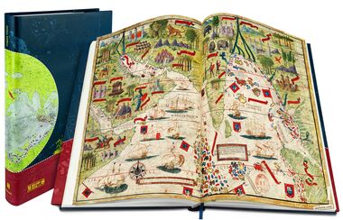
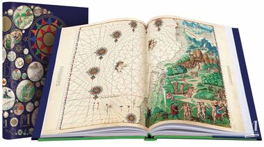
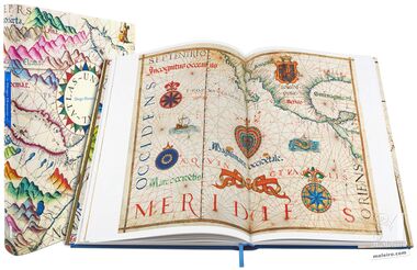
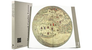
In the 14th century the Catalonia-Valencia-Majorca region was a flourishing centre of trade and culture where Arab and Jewish elements blended with Christian culture. Countless maps by this cartographic school have survived including the Estense World Map.
It can be considered to be a paradigm of the artist’s technique, logical extensions of his vision extending beyond the Mediterranean to the frontiers of the known world. The anonymous artist of the Estense World Map combined details from literature of certain regions of the world with empirical facts about the Mediterranean area, the zone he knew best. As a result, details from the tales of Marco Polo, known centuries before, can be seen in the descriptive outline of China, with details about the recent Portuguese explorations of Cape Verde, circumnavigated for the first time in 1444 by Dias too. Religion is also present in this map, not only due to the circular shape but also because of the drawing of Paradise, depicted in eastern Africa and not in Asia as was usual.
This books contains a smaller version of the map as well as a complete topographic transcription.
Leggi di più
Leggi meno
In the 14th century the Catalonia-Valencia-Majorca region was a flourishing centre of trade and culture where Arab and Jewish elements blended with Christian culture. Countless maps by this cartographic school have survived including the Estense World Map.
It can be considered to be a paradigm of the artist’s technique, logical extensions of his vision extending beyond the Mediterranean to the frontiers of the known world. The anonymous artist of the Estense World Map combined details from literature of certain regions of the world with empirical facts about the Mediterranean area, the zone he knew best. As a result, details from the tales of Marco Polo, known centuries before, can be seen in the descriptive outline of China, with details about the recent Portuguese explorations of Cape Verde, circumnavigated for the first time in 1444 by Dias too. Religion is also present in this map, not only due to the circular shape but also because of the drawing of Paradise, depicted in eastern Africa and not in Asia as was usual.
This books contains a smaller version of the map as well as a complete topographic transcription.
Formato: 305 x 568 mm
Pagine: 216
Illustrazioni: 289
Lingua: Spagnolo e Catalano
ISBN: 978-84-88526-22-9
SOMMARIO:
Vicisitudes históricas y fortuna iconográfica
Exploraciones geográficas, teorías cosmográficas y cartografía desde los orígenes hasta mediados del siglo XV
Cartografía italiana y catalana desde mediados del siglo XIV hasta mediados del siglo XV
El Mapamundi Catalán.
Descripción externa
El Mapamundi Catalán.
Descripción cartográfica
Conclusiones
Ernesto Milano
(Director de la Biblioteca Estense Universitaria de Módena)
Asedio dialectológico a la lengua
Joan Veny (catedrático emérito de la Universidad de Barcelona)
Transcripción del texto original
Annalisa Battini
(Bibliotecaria de la Biblioteca Estense Universitaria de Módena)
")
Formato: 305 x 568 mm
Pagine: 216
Illustrazioni: 289
Lingua: Spagnolo e Catalano
ISBN: 978-84-88526-22-9
SOMMARIO:
Vicisitudes históricas y fortuna iconográfica
Exploraciones geográficas, teorías cosmográficas y cartografía desde los orígenes hasta mediados del siglo XV
Cartografía italiana y catalana desde mediados del siglo XIV hasta mediados del siglo XV
El Mapamundi Catalán.
Descripción externa
El Mapamundi Catalán.
Descripción cartográfica
Conclusiones
Ernesto Milano
(Director de la Biblioteca Estense Universitaria de Módena)
Asedio dialectológico a la lengua
Joan Veny (catedrático emérito de la Universidad de Barcelona)
Transcripción del texto original
Annalisa Battini
(Bibliotecaria de la Biblioteca Estense Universitaria de Módena)