See more reviews
()
+ 7
One of the Most Important Atlases of the 16th c.
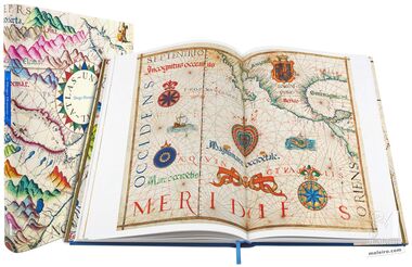
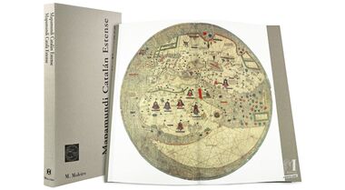
The Vallard Atlas (1547), ascribed to the Dieppe school of Northern France but with a distinctly Portuguese flavour, is one of the most important atlases of the 16th century. It is notable not only for its lavish illustrations, but also for what it represents in the history of global exploration. The atlas contains 15 nautical charts, and for the first time in history, depicts the coast of Australia 200 years before the voyages of Captain Cook. The abundant miniatures depict scenes of the colonisation which was sweeping the globe, as well as the daily lives of the local populations across the world, bearing witness to the Age of Discovery.
The Vallard Atlas, curiously, places the South at the top of the pages and the North at the bottom. This practice was in fashion amongst Muslim cartographers of the period, but was rare in Christian Europe. This is just one of the many characteristics of the atlas which make it both a mystery and a wonderful contribution to the history of cartography and exploration.
Written by a selection of experts in their respective fields, this 240-page luxury-edition full-colour book of art, complete with 210 images, sheds light on renaissance-era cartography, the intricacies of the Vallard Atlas and its well-earned significance in history.
Read more
Read less
The Vallard Atlas (1547), ascribed to the Dieppe school of Northern France but with a distinctly Portuguese flavour, is one of the most important atlases of the 16th century. It is notable not only for its lavish illustrations, but also for what it represents in the history of global exploration. The atlas contains 15 nautical charts, and for the first time in history, depicts the coast of Australia 200 years before the voyages of Captain Cook. The abundant miniatures depict scenes of the colonisation which was sweeping the globe, as well as the daily lives of the local populations across the world, bearing witness to the Age of Discovery.
The Vallard Atlas, curiously, places the South at the top of the pages and the North at the bottom. This practice was in fashion amongst Muslim cartographers of the period, but was rare in Christian Europe. This is just one of the many characteristics of the atlas which make it both a mystery and a wonderful contribution to the history of cartography and exploration.
Written by a selection of experts in their respective fields, this 240-page luxury-edition full-colour book of art, complete with 210 images, sheds light on renaissance-era cartography, the intricacies of the Vallard Atlas and its well-earned significance in history.